Thursday, November 15, 2012

Social Life of Small Urban Spaces

Below is the link to "Holly" Whyte's 'Social Life of Small Urban Spaces'. It's a really great movie, and if you have 60 minutes to spare, it's actually a pretty classic / enjoyable / amusing, and really revealing look at social behavior in urban spaces.

Here's a clip to give you a feel for the movie :


and here is the full movie : The Social Life of Small Urban Spaces.

Monday, November 12, 2012

Effective Graphic - Comparing Parks we all know about

http://www.alliedworks.com/projects/hudson-yards-boulevard-park-proposal/#/analysis/1

This one's for you, Cris! Btw, didn't you have something you wanted to post, Toni? Let's get back on the Blog bandwagon! We need to share our inspiration!

Friday, October 19, 2012

For 10/25 + Mid-Review (11/01)


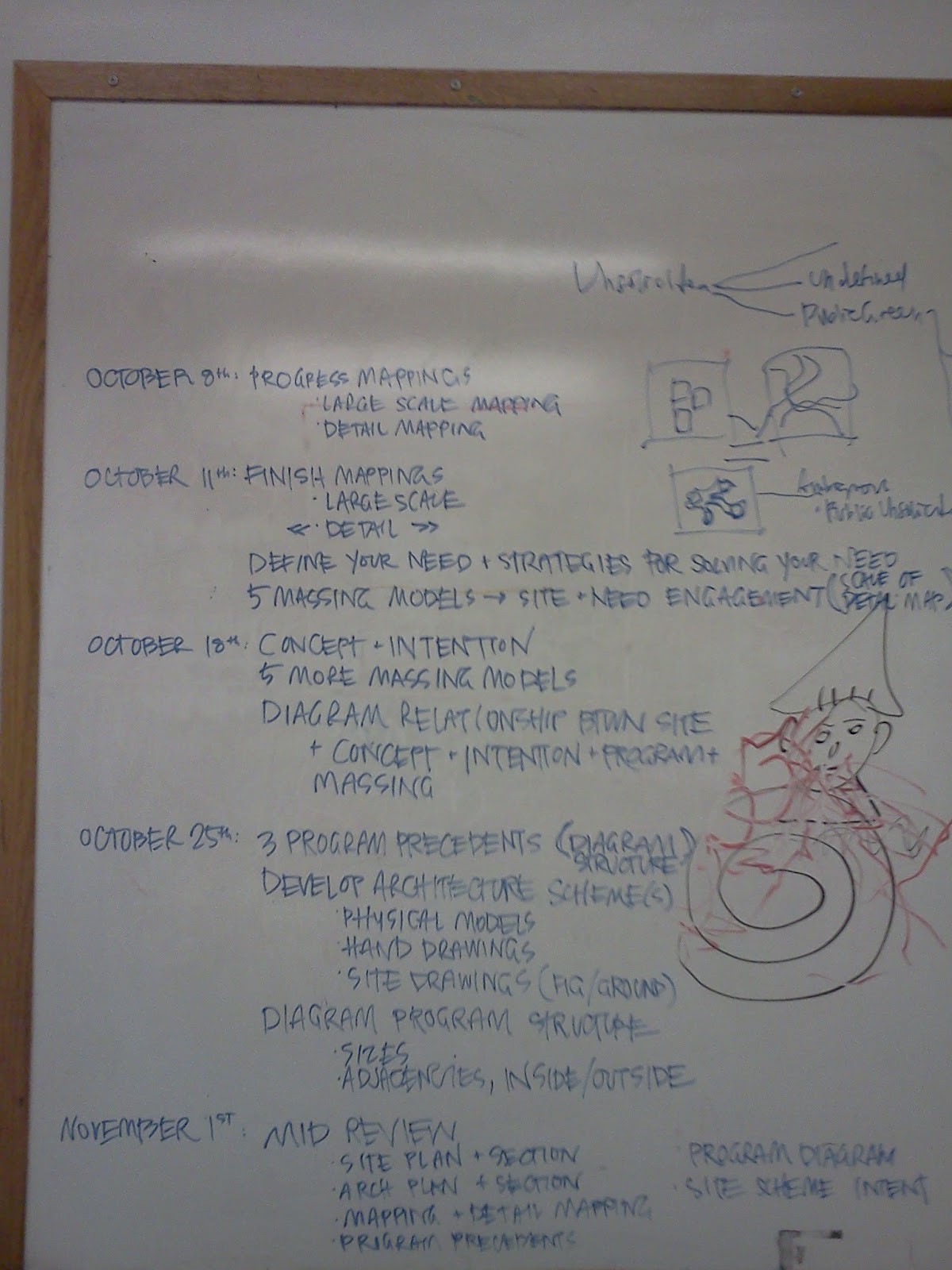
As you can see, I laid out the tasks for the next two weeks.  I tried to break them down, so they're a bit more doable.

Firstly, work on the second portion of the list for next week (aka 'Work On 18-25'). So, develop your chosen site, your massing approaches, your concept, etc. into an architecture (however roughly at this point) for next week. Do SCALE drawings (and know what scale you're working in). Consider its Program (if you're not ready to commit to one, describe several in diagram form). I have listed things to consider when working on your program diagram. (By the way, for those that were in class on Thursday, I'm nixing the photoshopping your model into a site photo. We'll get to that later.) Don't worry too much about the first part of the list for this week.

The reason is - the goal for October 25th is to have a version of all of the drawings, models, collages, renderings, etc. we plan to bring to the Mid-Review. They won't be final but they could be underlays and they will help you figure out how to present your project, what you're missing, what you don't need, etc.

For the week of Oct 25 - Nov 01, you will revise your maps (detail and large scale map) and work on any other site information you may need (like diagrams explaining why you chose that site, what your intervention does there, what is lacking, etc.) to make the jump into your architecture. And then you will also have to do more developed, revised, crafted, beautified versions of the second portion of the list.

Does this make sense? I know, lots to do, but you can do it! And please - let me know / post on the blog with Illustrator questions. I hope that tutorial was helpful, even if it was brief.

Aviva


O.M. Ungers designs for Bulfinch ! ?

Do you ever get the feeling that it's all been done before? I was doing research on 'Archipelago Cities' and ran across this image which looked suspiciously familiar . . .


Its actually a plan for Berlin by O.M. Ungers (1970's) for a 're-development' of Berlin in which the city's state of urban decay / depopulation became the ways in which Ungers suggested the city create highly urbanized components, surrounded by the open / un-built landscape, as a way of re-building the city while still taking into account the dwindling population / political constraints (Cold War).

Source, Abitare : City - Archipelago. Cities within cities #02

Wednesday, October 10, 2012

This is sort of relevant.

Residents in the North End are upset about a new development 

http://bostonglobe.com/metro/2012/10/09/development-plan-for-waterfront-pavilion-pits-north-end-residents-city-officials/9QkB006KsrsdpqXZbXTTrL/story.html

Monday, October 8, 2012

Check it out y'all! Schedule until Mid-Review!

I will send you an email with this info as well - especially for those that couldn't be at the meeting tonight. Lots to do!!

Friday, October 5, 2012

Deadlines + Reminders

Hi all -

Did you guys go to the lecture yesterday?? I hope so! I'm sure it was very interesting and potentially inspiring. I also hope you all recovered from our wet and early site visit this past Sunday. My apologies for the terrible timing of weather. But please use your mapping themes as lenses to re-look at the site. And how did your 'notations' work out? Did they help you quantify, qualify, and locate the information in analysis? Please incorporate these into your mappings!!

Reminders!

  • Cris: did you post the re-scaled maps? Everyone have them?
  • Everyone: have you tested the scale of your mapping? Does 1"=100' work for 24" x 36 (in either orientation)?
  • Everyone: Does 1" = 50' work for your detail map?
I would like you guys to all email me your progress in the next two days and I look forward to seeing them in more detail on Monday, October 8th from 6pm - 7pm. The BAC will be open on Monday, despite Columbus Day, so we can meet in the 320 Newbury Street building and I have contacted them about reserving a room for us for the hour. I'll let you all know where that will be. But for now, just expect to meet at 320 Newbury Street.

Deadlines!
  • Send me your progress before Sunday night!
  • For Monday October 8
    • A revised Mapping at the larger scale (1"=100') (24" x 36" print out - can be multiple boards )
    • A Detail Map at a smaller scale (potentially 1"=50' - but someone let me know how that works) paper size is up to your discretion
Lots to do in the coming days! Please send me questions, thoughts, issues you're having since our last crit / discussion. K? Anything else?

I'll email this info out to you all as well!

See you Monday!! Aviva

Monday, October 1, 2012

Thursday October 4th Lecture at the GSD


Hey Guys, except Aviva since she'll be gone,

There's a lecture this Thursday at the GSD which I thought might be a fun 'replacement' for Studio. Let me know if you want to go. I thought it might be nice to meet-up either before or after and possibly talk about our mappings / bounce ideas off of each other. Just a thought.

- Aaron


Thursday, October 4

6:30pm Piper Auditorium
"City as Territory as Landscape," a talk on the nature of outdoor spaces by Zürich landscape architect Günther Vogt. Vogt has collaborated with architecture firm Herzog & de Meuron on the Tate Gallery of Modern Art and the Laban Dance Center in London, as well as the Allianz Arena, Munich; he also worked with Gautschi Storrer on Zürich's Masoala Rain Forest Hall.

Friday, September 28, 2012

Cool Mappings in Cambridge!

Check this out: http://www.cambridgema.gov/solar/


Maybe there is something like it in Boston? Invisible infrastructures anyone? :)

Mappings (continued)

Think of these 'titles' as a NEW way of approaching typical map themes. And push back on my 'titles' - what is more fitting for you? Toni - what is your focus? For example, one could look at 'crime' through the lens of demographics, institutions, open space, and transportation. How? What patterns emerge?

(Please note: the red are elements we (as a studio) haven't yet included or dealt with that may be of interest to your larger design pursuits)

Wednesday, September 26, 2012

On maps

Maps to me don't have to be quite as rigid as what seems to be the general definition of a 'map.'
When you're little in school you learn geography and the states and capitols and the locations of all the countries in the world. And maybe you remember these and maybe you don't, and maybe it's because you learned a song, or maybe you assigned specific colors or patterns to these regions and that was helpful. But maps to me can be more fluid, and representational than geographically accurate. Take the Nolii plan, for example. While accurate, you're attention is not drawn to 'oh, look Massachusetts is pink,' or 'Finland is sort of shaped like a finger,' your attention is drawn to the similarities and differences of what is solid vs. what is void. The information maps offer can be more fluid and workable, as in diagrams, to convey a message or an intent. I think that laying information on top of each other in form of a map is often beneficial, but to me sometimes maps loose their beauty or significance when too much import is laid upon "accuracy."

Nolii plan

Mutable Maps

Thoughts.

There is a small part of the reading mapping reading i'm skeptical of, Cosgrove explains that the maps can free the reader from the confining perspective of the photograph or painting. I don't want to undermine
the idea completely because I can see how that might be the case but I would argue that it is more the
cartographer who is freed from the constraints. The reader Cosgrove is speaking of is left only with
the distilled information the cartographer wished to convey and is perhaps more confined than before.
That said the added restriction is the maps primary virtue, if for example the reader wishes to see a
map of roads in a particular region they don't want to be disrupted by topographical information as well
and so a map of restricted to highways alone is more suitable. In this way the reader had been freed of
unnecessary information but perhaps not perspective.
This particular aspect of mapping relates well to my experiences with mapping our current site. In
most regards creating my map has been an endeavor in finding what my perspective is. If I were to
include all the information I could the map becomes illegible or misrepresented and what I wish to
show becomes clouded and unapparent, similarly too little information and it represents little. My final
thought is that the map exists in a state of mutability, as selected information is coming together I expect connections will be made which I will want to then emphasize by altering the content.

Saturday, September 22, 2012

Cartograms

I spent quite a deal of thinking on the section entitled 'Mapping Meaning Into the Map' starting on page 9.

Scale, framing, selection, and coding add meaning to a map.

Scale being the most important, in my opinion, because we all have the same sense of 'scale'.  Generally, humans use everyday objects to help describe a metric without using a number.  Two car-lengths.  5 football fields.  4 arms-lengths.

We all can imagine sizes and distances based on these 'measurements'. 

I started thinking about taking away the 'comfortable' scale and using a distorted sense of scale to push an agenda/intent/idea.  Take away our conventional sense of scale on a map and one must focus much more intently on the content and relative relationships shown.  Cartograms are such things.


Above is a map of the world 'distorted' to represent a country's size based on its wealth.

Is this map inaccurate?

What is an accurate map?

I think this method of looking at scale raises the question: Are maps with 'true' scale accurate? To whom and to what end are they accurate.

Do you learn MORE about the world from this map or from the cartogram?


An interesting article I read this past summer: What Transit Maps Reveal about Cities - Dwell

Friday, September 21, 2012

GoogleMaps; it's up in yo' bizness . . .

Considering this week's reading is all about mapping I thought I'd share this new discovery . . . apparently GoogleMaps now has been mapping the INTERIORS of stores / businesses . . .


. . . well this certainly changes the mapping of things . . .

Saturday, September 15, 2012